National Hurricane Center watches new tropical waves amid peak hurricane season

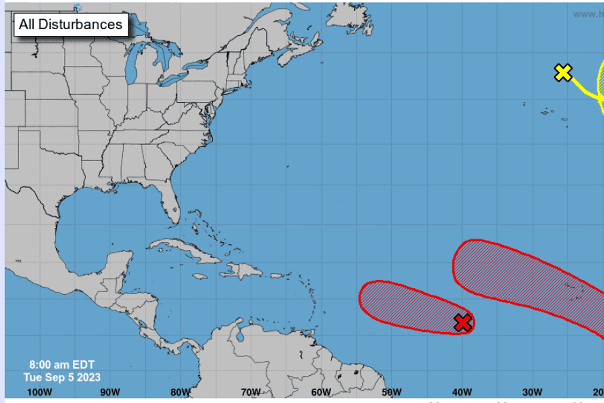
MIAMI – The National Hurricane Center forecasted the likely formation of two additional tropical systems into cyclones in the coming week, as part of waves coming off the west coast of Africa during peak hurricane season.
The Atlantic hurricane season began June 1 and ends Nov. 30. “Peak” season occurs around Sept. 10.
Major Hurricane Idalia still fresh in mind, Florida meteorologists are keeping an eye on Invest 95L, which could take the name Lee in short order.
The National Hurricane Center has no official “cone” yet because the storm has not yet officially formed; when it does and as it moves further west across the Atlantic, the “cone of uncertainty” will be forecasted.
Invest 95L, potentially future Lee, is only currently forecasted to approach, but not yet reach, the Leeward Islands, traveling slightly northwest.
Modeling suggests that the approaching storm will curve north, away from Florida, but WINK chief meteorologist Matt Devitt noted that it’s “too early to guarantee” the path so far away from the present, especially when the system is not formed.
Models are not official forecasts. Seek official information from the National Hurricane Center, which will come as the storm forms and gets closer to the U.S.
Despite optimistic trends painting a turn away from the U.S. Southeast, the storm is still modeled to become a major hurricane, which means a storm above Category 3 wind speeds – at least 111 mph.
WESH meteorologist Eric Burris clarified that while models agree on the storm continuing to travel northwest, there is a lack of agreement as to the degree the storm will turn.
Storms can buck models’ predictions so far out. Hurricane Florence in 2018 was predicted to turn away from the U.S., but that modeling came far out from the storm’s landfall date.
When landfall got closer, the storm was indeed forecasted to land in North Carolina. The National Hurricane Center’s official forecast did hint at a turn northernly earlier on, but their forecast was ultimately accurate, serving as another reminder to keep an eye on the official “cone of uncertainty.”
Some of Florida’s most notable hurricanes occurred between late-August and mid-October, the time in which Atlantic hurricane season becomes more active.
Hurricane Irma, a Category 5 storm that traveled just north of Cuba all the way from Africa’s west coast, made landfall in Florida on Sept. 10, 2017.
Hurricane Michael, a Category 5 storm, hit Florida’s Panhandle on Oct. 10, 2018.
Hurricane Ian also briefly became a Category 5 storm, and it made landfall on Sept. 28, 2022.
Hurricane Idalia was Florida’s most recent, making landfall just last week on Aug. 30. It became a Category 4 storm before making landfall.
Florida’s recovery from Idalia is ongoing, with power outage restorations being a high priority for Gov. Ron DeSantis’ administration. He announced Monday night that more than 95% have been restored under a week since landfall.


